On moving to Goa

‘You have never been to the sea?!’ Yes, 27th July 2022, was when I headed out for Goa, and the sea, for the very first time. As usual, I had to leave my home in Bongaigaon, Assam, a day or two before my scheduled departure. Because travelling 185 km to Guwahati Airport on the day of departure, has always felt risky to me. At 8:45 AM, I boarded the flight from Guwahati, and by 2:40 AM, I was in Goa! After booking the pre-paid taxi and walking out of Dabolim airport, was when I said to myself, ‘Okay, the journey begins.’

Something about Goa that I observed and loved was the greenery as seen on my route from the airport. Before my arrival to Goa, I was assigned a task on mangroves to work on, and on the way to the city, I saw mangroves for the first time ever - it was amazing!

I was staying with one of my colleagues; after reaching, she welcomed me with a hot bowl of Koka noodles in her warm house. Strange, though this was the first time I met two of my colleagues, the warmth felt familiar. Later that day, I started house-hunting in Panjim with another colleague.

On the following day, we had a team meeting with the Mongabay-India team. While the discussions were on, we were offered some snacks; that’s when I tried bhakarwadi for the first time. It was delicious!

After a team dinner, we headed towards the Vagator beach around 11 pm. I had this kind of giggly excitement for I had never been to the sea. As it was pretty late, most shops were closed. We crossed through lanes with shops that sell crystals; ‘How fascinating!’ I wondered.

About 30 metres from the ocean, we could hear the sound of the waves crashing onto the shore. The sea was still not visible, but there was a cold breeze. A few more steps and I glanced at the sea; it gave me chills. With loads of mixed feelings rushing in, I walked head down, and only when I reached the shoreline did I gaze at the small white waves rushing in, only to return to the dark infinity. Rest of the team waited for my reaction to seeing the sea for the first time. And I never imagined my first encounter with the sea to be scary. 

I never imagined getting to do the things I was doing at the moment. Another day we drove to a local quarry to train with Varaha (our cute ROV).  Watching the turquoise blue waters that day, I regretted not knowing how to swim.

A few days later, we made our way to Caranzalem beach, not the usual way but through a narrow trail that felt like it was a scene from a movie. This time the sea was magnificent with the orange and pink hues of the setting sun. However, I had this dizzy feeling of being pulled away into the ocean by the waves. For a person who would lose balance in the pool, now witnessing such a large body of water was quite a big step towards conquering the fear of water itself.

Trail leading to Caranzalem beach.

On the weekend we drove to a point on top of the hill, where one could see the whole extent of the Caranzalem and Miramar beaches. It was early on a cloudy morning, and few fishermen were out with their boats. Some dogs accompanied others on foot, with crows, black kites, and stunning Brahminy kites flying high, just about where we were sitting. I witnessed the Brahminy Kite for the first time; in bright white and rustic orange, shining from the sun rays from the parting of the clouds that fell on it; it was majestic. It was soon after that that two tiny birds with tints of yellow and blue came crashing, fighting with each other, halted, noticed there was a human next to them and so quickly flew away. The next thing I did was I took out my phone to Google it and found out they were Olive-backed sunbirds. I was absorbed in the rush of excitement when something moved in a  palm tree nearby; it was a Greater coucal! Next, my colleague pointed toward two grey, big-headed flying birds. For a while, we watched the movement of what were most probably the same birds in a nearby tree. However, the canopy was too dense to see through. With a few glances and some Google searches later, we guessed that they were Grey hornbills. It was a beautiful morning, well-spent bird-watching and learning about them.  

The whole extent of Caranzalem and Miramar beaches.

Talking about birds, we recently went to Dona Paula beach, where we saw a big bird far away, near where the fishermen were fishing. I was sure that it was not a kite. It flew away from the beach, and I was sure what I saw was an angelic figure that had white on its body. But I didn’t know which type of falcon it was. It looked so magical. I was curious and hopeful that it would fly back, but disappointed, it didn’t, and it stayed on my mind for days. 

Recently, we went to a forested area where the river Mandovi met the Arabian sea. As we were staring up at the canopy covers of the oak trees, a big falcon came flying gracefully to the top of the canopy, displaying its white, greys, and blacks. It was the same angelic figure that I saw the other day. It was a white-bellied sea eagle, and yet again, it was playing the game of hide and seek. To get a clearer view, we walked closer to the river's embankments, but it had decided to forever play its game of hide and seek. Standing near the embankment, we saw Brahminy kites making their rounds- near the water and the fishing boats. The crows kept cawing, trying to chase the Brahminy kites away, missing their shots. And the  kites kept doing their business calmly, not minding the caws. And just when we were watching this play, there came the White-bellied sea eagle! Gracefully taking a round and vanishing into the canopy. While I was partially satisfied to see it again, its game of hide and seek only made me more eager to search for it. Apart from that, we also saw a wiggling Common Sandpiper. The white streaks on its wing bars when it takes flight are a sight to behold. And lastly, just when we turned back from the end of our trail, something flew in front of us and sat on a wire. So tiny! It was a pair of White-rumped Munias. They were very cute! We observed them for some time, and while they did not seem to be leaving anytime soon, we decided to leave. 

The White-bellied sea eagle in the middle.

Goa, for me till now, has been amazing. From meeting my colleagues for the first time to meeting the sea for the first time. From meeting a lot of new birds to having a crush on the White-bellied sea eagle. Moving to Goa has been wonderful!   

Conservation Cartography with Mongabay-India (Part V)

We began our collaboration with Mongabay-India to enhance their stories with our spatial analysis expertise. Our shared objective to diversify environmental awareness to communicate to a larger audience continues as we embark on our second year of collaboration.

From October 2021 to June 2022, we’ve worked together to produce 30 maps and map-related/cartographic media for 23 stories in 11 different verticals by Mongabay-India. This blog documents the final set of articles we visualised together from October 2021 to June 2022.

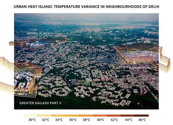
[Illustrations] Why are temperatures within a city’s neighbourhoods different?

The minimum and maximum surface temperatures of three Delhi neighbourhoods with varying socio-economic and physical characteristics were taken around noon on May 3, 2021. The range of temperatures in a given neighbourhood is stacked in intervals of two degrees Celsius and represented in the illustration. Illustration by Alisha Vasudev/Mongabay.

Urban Heat Islands in a city can have different temperatures not only between the city and its surrounding areas, but within a city itself.

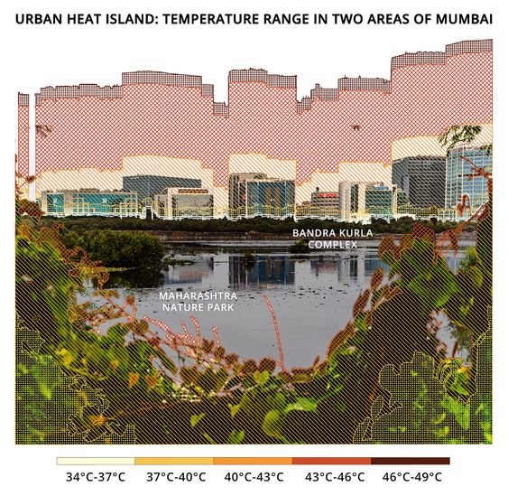
We gathered data from different neighbourhoods in Mumbai and Delhi, using Landsat 8 ST_B10 band and processed the data using Google Earth Engine. Alisha Vasudev/Mongabay has illustrated the range of temperatures in a given neighbourhood for recorded minimum and maximum surface temperatures at a given time, on a regular summer day in 2022.

The minimum and maximum surface temperatures of two Mumbai neighbourhoods, with different physical characteristics, were recorded at 11 am on April 15, 2021. This illustration shows which temperature range (in intervals of three degrees) is recorded in what percentage of the area in each of these neighbourhoods. Illustration by Alisha Vasudev/Mongabay.

Maximum Land Surface Temperature in India, 01 March - 31 May 2022

According to experts, India's heat action plans need to incorporate long-term measures including efforts to decrease indoor temperatures, be regularly monitored and updated, and be more proactive to decrease heat stress.

(Note: This is the fifth blog in the series, on our collaboration with Mongabay-India. Read the previous blog here, and the first in the series, here.)

Using PARIVESH for effective conservation advocacy

The following article authored by Pakhi Das, Shashank Srinivasan, Nancy Alice, Ashwathy Satheesan, Nandini Mehrotra and Anand Srinivasan was first published as ‘The PARIVESH Portal: Pros, Cons And How To Use’ by Sanctuary Asia on 03rd August, 2022.

Until July 15, 2014, the process for any development project to obtain a green clearance in India involved several stages - the circulation of physical project files between different officials at multiple stages of approval. File access was limited to the government, the applicants seeking green clearances, and the authorities granting approvals. Moreover, the complex nature of clearance processes and the lack of accountability created a lack of trust in the process.

To remedy this and to ensure better transparency and efficiency in the clearance process, the Ministry of Environment, Forest and Climate Change (MoEFCC) has established the PARIVESH website.

PARIVESH stands for Pro-Active Responsive facilitation by Interactive and Virtuous Environmental Single-window Hub. It is a web-based, workflow application that has digitised the entire process of submission and monitoring of Environment, Forest, Wildlife, and Coastal Regulation Zone (CRZ) Clearance proposals submitted by proponents to the Central, State, and District Level authorities. The portal allows project proponents to register themselves and submit applications for various green clearances in digital formats. Although seemingly designed for project proponents, PARIVESH has become a valuable resource of collated information that is open for viewing by the general public.

There are currently more than 10,000 land-use proposals submitted for clearance at the MoEFCC in India, ranging from the construction of multi-state national highways to the establishment of small-scale cottage industries. Various government officers and committees are assessing the potential impact of these proposed projects before granting approval.

The Benefits

The PARIVESH website hosts an enormous amount of information about all old and new projects seeking green clearances, organised by state, year, category and stage of approval. The information comprises spatial data regarding the outlines of the project site location and alignment, the area of forest land being diverted, site inspection, and biodiversity assessment reports. Such information is of immense value for conservation and is freely available on the portal.

Using the appropriate search functions, project information concerning any given project is available for viewing or, in some cases, even downloading. The portal also hosts details of discussions of various expert committees through the agenda and meeting minutes, allowing people from outside the system to view and analyse the processes that ultimately affect India’s wildlife and environment. All the relevant information is presented as an application package with downloadable file attachments, which could prove beneficial for conservation research and advocacy. The quantity and variety of information on the portal make it a treasure trove for anyone and everyone interested in the green clearance space of India.

Information that can be found on the PARIVESH website about any development project in India:

1. Area sought for clearance
2. Project cost
3. Spatial information about project location in KML (Keyhole Markup Language) format, details of the land required for clearance such as forest division names, area of forest and non-forest land, village and district wise breakup of the total proposed land, etc.
4. Details of Project Proponent/User Agency
5. Cost Benefit Analysis undertaken
6. Status/links to associated environmental or wildlife clearance (if any)
7. Project plan/ feasibility reports/ site inspection reports

Non-user Friendly Interface

While introducing PARIVESH for digitising the green clearance process in India helps to bring about transparency and accountability in the system, the portal is not user-friendly and is cumbersome to navigate.

The system should be able to streamline important projects and allow easy access to relevant information however, most of the files are not appropriately tagged, making the search options unreliable. To be able to ‘find’ specific projects within a timeframe, the user must know specific project details such as the exact name of the project, project file number, and the clearance level.

Additionally, green clearances are complex processes and involve multiple levels of reviews and recommendations from various government departments. These processes are broadly divided into three clearance verticals, namely Environmental Clearance, Forests Clearance, and Wildlife Clearance. Each of these verticals has its own set of processes and organisation hierarchies that the project file must circulate through at the level of first the state and then the centre. In the instance that a user is able to trace the details of a particular project on the platform, comprehending what stage of approval that project could be at and what that stage of approval entails is a task in itself.

Problems with the PARIVESH website

1. Low Discoverability: Navigating through the PARIVESH portal is complicated as information is not organised uniformly across types/categories and sometimes even regarding regions.
2. Decision Fatigue: Because of the structure of the portal, too many steps are involved in obtaining a particular project’s information
3. Inappropriate Project Tagging: Proposals, projects or additional attached documents are not appropriately tagged, which makes finding them using the search function cumbersome.
4. Complexities of the Clearance Processes: The complexities of the clearance processes and organisational hierarchies make access to information additionally difficult. The portal does not describe the various stages of approval under different clearances.

How Can This Be Improved?

For effective conservation advocacy, knowledge of potential areas of intervention is crucial, which makes a clear understanding of what happens at each level of approval imperative.

Simple features, such as an option to view projects cumulatively across the clearance types, or to view projects on a spatial platform, would increase the efficiency of the portal manifold. The dashboards for different types/verticals of clearances use abbreviations for the stages of approval with no description of what those abbreviations stand for nor what each of those stages entails, thus creating a limitation in the understanding of the clearance procedures altogether. Furthermore, there is a lack of features that would allow users interested in specific projects to subscribe or receive notifications for any updates on the approvals.

PARIVESH, although perhaps designed for project proponents seeking clearances, has been a useful portal for other stakeholders. The inclusion of features such as these would revolutionise accessing vast amounts of publicly available data for all stakeholders and will allow them to be more involved.

To truly achieve the goal of increased transparency and efficiency in the green clearance process in India, providing better access to information is key. India has a growing population of aware citizens from an array of backgrounds and a better system would greatly empower them to play an active role in determining the future of the environment, forests, and wildlife of the country.

Flowchart illustrating an user agency’s process in PARIVESH.

How to Use PARIVESH: A step-by-step guide with tips

PARIVESH hosts a large volume of project information, which is of immense use for awareness, campaigning or advocacy. However, navigating the portal to get to relevant information often involves many steps. It is important to narrow down search to the farthest extent possible by applying relevant filters. One might also have to scan through multiple project forms and verify information from other media articles and web reports. However, if a project is cleared, it is mandatory for it to have gone through PARIVESH, and information about it must be available on the portal. Here's how to access this information.

Step 1: Make a list of all the known information about the project one is seeking information on

For example, let us do so for the Etalin Hydropower Project.

Critical known information about Etalin hydropower project
- State name: Arunachal Pradesh
- Area: Dibang Valley
- Project Proponent: Jindal Power Ltd.
- Category of Project: Hydroelectric/hydel
- Date proposed: Before 2016 (although not crucial, it is often helpful to review other existing information/media reports about the project of interest. Information such as the timeline of the project helps in narrowing down search)

Step 2: Explore PARIVESH Portal

Note: All projects proposed on PARIVESH are organised according to the type of clearance sought into three categories -- environment, forest and wildlife clearance.

To find information, each of these types can be explored independently. The following sections provide a step by step guide to navigating the portal.


For Forest Clearance
1. Open https://parivesh.nic.in/ homepage, scroll down and select ‘Forest Clearance’.

2. To view all forest clearance projects, select ‘Dashboard’ option on the header.

3. Once clicked dashboard, apply filters to narrow down search filters such as state, category and hit search.


Note: Projects under forest clearance on PARIVESH are organised in two categories - Stage I and Stage II. If the status of clearance of the project is known, lead search by that status. However, if this information is not known, explore both stages.

4. To view all Stage 1 projects, click on the ‘Form A part II, Under Stage I’ button on the dashboard. As seen below, there are a total of 12 hydel projects proposed in Arunachal Pradesh, which are currently under stage 1.

5. Click on ‘ACCEPTED’ (these are all the relevant projects according to the applied filters).

6. A dataset of all projects as per the chosen category will be displayed with unique project IDs, and other relevant information, which should allow one to review and identify the project of interest.

Things to note while trying to identify project of interest:
(i) Is the project proponent the same as known information? Eg. Jindal Power Ltd.
(ii) Is the forest division/area the same as known information? Eg. Dibang Valley.
(iii) Is the project proposed in the known timeline? Eg. 2015.

(Screen grab of all hydel projects in Arunachal as on May 5, 2022)

7. Each project has a corresponding form, which hosts information about the project.
To view this information and to recognise project of interest, click on magnifying glass icon under column titled ‘View Report on Allocation of Fresh Forest Land (Form-A) Part-I’

8. The Form A part I includes information such as the forest division details, area for clearance, spatial data, additional documents, etc. all in downloadable formats.

9. All the documents and the form itself can be downloaded as PDFs. It is important to note that until the project is granted final clearance, the proponents can make edits, add or delete files on the portal.

Note: The precedent blogpost on decoding and navigating PARIVESH can be read here.