In 2021, we began collaborating with Mongabay-India to enhance their stories with our spatial analysis expertise. Our joint goal is to use diverse storytelling formats to expand conservation awareness and reach a wider audience. This blogpost documents the first five articles we’ve worked on together, starting in October 2021.
Stone mining in Brahmagiri mountains chips away at the Godavari River ecosystem
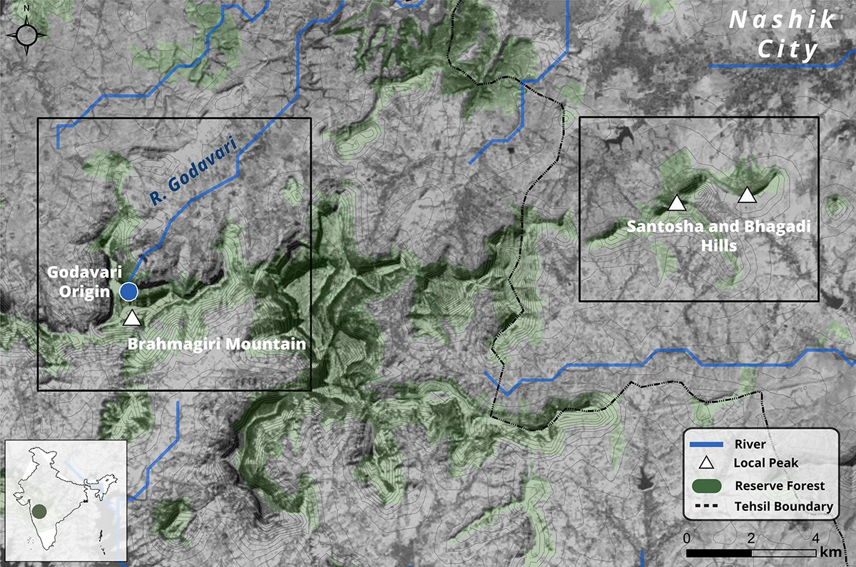
Location of the Brahmagiri mountains and Santosha-Bhagadi hills near Nashik city in Maharashtra. Reserve map boundary by Nashik Forest Department.
This article highlights the human interventions in the natural flow of the Godavari and the subsequent impact on its ecosystems. We worked on a map depicting the Brahmagiri mountains and the Santosha-Bhagadi hills near Nashik city in Maharashtra.
From pollution to power, what stops paddy straw from becoming the fuel of choice

Spatial data on fires in Punjab and Haryana was acquired by the VIIRS instruments on the Suomi National Polar-orbiting Partnership and the NOAA-20 satellites. Each fire pixel represents the centre of a 375m x 375m area that contains actively burning fires.
The article walks us through farmers' management of surplus paddy straw, the cost, the options of using the same to produce energy at biomass power plants and biogas units and why farm-fires are a common instance post- harvest season in North India.
The above visualization from spatial data on fires in Punjab and Haryana was acquired by the VIIRS instruments on the Suomi National Polar-orbiting Partnership and the NOAA-20 satellites. Each fire pixel represents the centre of a 375m x 375m area that contains actively burning fires.

PM 2.5 indicator in Punjab and Haryana during the stubble burning season.
PM 2.5 indicator in Punjab and Haryana during the stubble burning season. The darker the pixel, the greater the concentration of PM 2.5. This map was created using CAMS ECMWF (Copernicus Atmosphere Monitoring Service European Centre for Medium-Range Weather Forecasts) PM2.5 data processed in Google Earth Engine. We have a separate blog post describing the technical process behind this visualisation here.
Chennai’s fight to preserve its wetlands and stay above water
The report notes the importance of conserving freshwater marshes that act like sponges storing the heavy monsoon rains and releasing water during dry months. It also reports the efforts from the government of Tamil Nadu to conserve the Pallikaranai marsh, the last remaining freshwater marsh in Chennai. We worked with Mongabay-India to visualise Pallikaranai Wetlands shrinking acreage from 2450 ha in 1991 to 700 ha today.

Buxa Tiger Reserve
An adult male tiger was recently recorded on a camera trap in Buxa Tiger Reserve in north Bengal after 23 years. Mongabay-India writes on the ecosystem restoration activities in the Buxa Tiger Reserve, including grassland management that experts say helped bring the tiger back to the protected area.
We worked on a locator map for Buxa Tiger Reserve (BTR) located in Alipurduar district of West Bengal which is contiguous to Phibsoo Wildlife Sanctuary, Bhutan in its north.

Urban Expansion in Bengaluru district
The report weighs movement of snakes and other urban wildlife against the rapid urbanisation of Bengaluru. We worked on visualising the rapid urbanisation of Bengaluru district from 1995-2020. Water bodies and vegetation cover decrease as urbanisation increases.
(Note: This is the first blog in the series on our collaboration with Mongabay-India. Read the second blog here)