Helping Ensure Ethical Indian Drone Operations

This blogpost was originally posted on the WeRobotics blog (link) on the 8th of October 2020

The global civilian drone industry is currently in a growth phase. From its initial beginnings in the mid-2000s as a hobbyist activity to its warranting regulatory supervision to its current status as a potential game-changer for national economies, the drone industry seems to have weathered it all. Even with the pandemic and associated lockdowns, the drone industry still has the potential to grow, providing as it does the option of ensuring that work gets done safely and hygienically. Over these years, the number of both drone users and the various applications of drone-acquired data have grown massively. 

It’s possible for a project to comply with existing regulations and legislation, and even be commissioned by the state, and still be deficient from an ethical perspective.

As with most emerging technologies, drones have influenced and exacerbated a plethora of complex social interactions. When drones are used without adequate consideration of their impact, they can inflict serious harm on individuals and communities. In India, policies, regulations, and social norms around drone use have not kept pace with the technological applications, especially around what constitutes safe and ethical drone use. At Technology for Wildlife, we are conservation geographers and drone pilots; thus, we are also participants in the Indian drone industry. We’ve come to realise that accepting certain work proposals would put us in ethically complicated and questionable situations that could potentially compromise our desire to do good. However, each time we choose to decline a project that does not fit with our values, we know there are enough other drone operators out there for the project to go ahead anyway. It’s possible for a project to comply with existing regulations and legislation, and even be commissioned by the state, and still be deficient from an ethical perspective. There is a clear need to create and implement guidelines for the drone industry regarding the ethical operation of drones to complement the government-mandated regulations.

In this context, in late 2019, we applied for the WeRobotics Unusual Solutions Competition, intending to understand what would be required to have participants in the nascent drone industry commit to conducting ethical operations. Today, we’re pleased to present our work in a report titled: Towards Incorporating Ethical Considerations into Indian Civilian Drone Operations

UnusualSolutions_Shashank_Slides_25Feb2020_v1.jpg

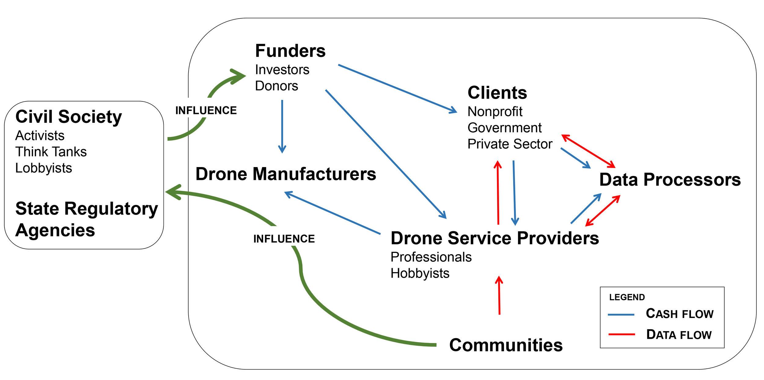
Rather than providing prescriptive rules on ethical operations, we’ve used our research and sectoral knowledge to put together a roadmap to what we believe ethical drone operations should look like in the Indian context, and how and why specific stakeholders should be engaged. This report is intended (to quote from it directly) for “anyone in, or engaging with, the drone industry and will be particularly relevant to those who intend to build solutions that would address the social implications of civilian drone use.” While we have focused on the Indian drone industry, it is quite likely that our work is also applicable to other countries with similar contexts.

We hope that in these troubled times, this report is one of the many pieces required to ensure that drone operations are empathetic, considerate, and ethical, both in India as well as globally.

How we use Excel for geospatial data analysis and visualisation

I’ve been giving a number of online talks over the past few months, talking about both the general nature of our work as well as about how we accomplish specific technical tasks. During one session of the latter type, I mentioned how a lot of our GIS work actually happens in MS Excel and one of the audience members wanted more information on what that actually entailed. I attempted an answer then, but a GIS task this morning really highlighted how much I need and love MS Excel. I’m going to use this blogpost to document exactly what I did, so if I’m ever asked this question again, I’ll have some documented proof to support my response!

In brief, I was provided with an Indian Government gazette notification detailing the locations of a set of offshore mining blocks off the coast of India. This was in PDF format and while it comprised both text and tables, the relevant data was in tables alone. There seemed to be only 60 or so rows of data, with about 9 columns. In the distant past, I would have just hand-coded the entire thing using the num-pad on my keyboard, but this time I used one of my new favourite OCR tools (Convertio) to rip the relevant pages of the PDF into a Word document. The tables were then copy/pasted into Excel, and that’s where the real work began.

The original data columns in the gazette notification PDF

The original data columns in the gazette notification PDF

As can be seen from the image above, the spatial information is in an odd format, not really ingestible by most GIS software which needs, at a minimum, coordinate pairs to represent points. In addition, I prefer working with decimal degrees rather than the degree-minute-second format as I’ve had some traumatic experiences with apostrophes and quotes in GIS software. So, now working only in Excel, I first did a quick check/fix to catch the few errors from the OCR process ( 8’s read as 3’s, 7’s read as 1’s), I created four new columns (Lat_E, Lat_W, Long_S, Long_N). Each deg-min column pair was converted into a decimal degree format in one of the new columns using the standard conversion formula [ Decimal Degree = Degree + (Minutes/60) + (Seconds/3600)]. I also created a unique ID (UID) for each row by combining the grid number with the initials of the area; for example, Block 12 in the Arabian Sea has a UID of 12_AS.

Now, for the more complex part; GIS software can ingest text files and visualise spatial data as points, lines or polygons. My desired output for this task was a demarcated text file which had all the information required to visualise each offshore mining block. One method would involve creating 3 new rows for each block record, where each row would eventually contain the coordinates for the NE, NW, SE and SW points. This could be done manually, using cell-handling commands in Excel but would be a lot of very boring manual labour, and I would then need to combine the points together in a GIS package to obtain my polygons. Alternatively, I could write a short piece of Python code which would convert the Excel sheet into a GeoJSON file with the appropriate geometry attributes. This is the most powerful of all available options, but felt like overkill for this task.

Instead, I created a new column and put together a quick cell-handling formula that converted the spatial information into a Well Known Text (WKT) polygon format that GIS software such as QGIS is capable of reading. The formula itself looked like this

=CONCATENATE("Polygon ( (",O2," ",M2,", ",P2," ",M2,", ",P2," ",N2,", ",O2," ",N2,") )")

where the cell reference numbers refer to the (Lat_E, Lat_W, Long_S, Long_N) columns in the correct pair-grouping to obtain the NE, NW, SW and SE corners of each offshore mining block.

The converted lat-long data in four columns, as well as the WKT-friendly polygon information

The converted lat-long data in four columns, as well as the WKT-friendly polygon information

The file was then saved as a Comma-Separated Value (CSV) file. I used QGIS to read the file, selecting the WKT format as the input option, and the polygons appeared! After a quick geometry repair process, I configured the labels, exported the file in KML format for visualisation in Google Earth Pro and also created a rough static map, and the task was complete.

This is just one among the many ways in which we’ve used Excel to do the initial heavy lifting for spatial analysis and visualisation tasks, reserving the more specialised GIS tools for when they’re really needed.

A rough map depicting the final polygons

A rough map depicting the final polygons

26 projects approved by the Indian National Board of Wildlife on April 7th 2020

On 7th April 2020, when India was under a national lockdown due to the COVID-19 pandemic, the Standing Committee of the National Board of Wildlife (NBWL) held a virtual meeting and discussed 31 proposals regarding projects inside or within 10km of protected area. 26 of these projects were approved, of which 9 are for limestone mining near Mukundra Tiger Reserve; we’ve bundled these up together to prepare the 18 stories in the story map below.

Since most citizens are unlikely to read through the dry and detailed minutes of official meetings (PDF here), this story map is meant to be representative and informative of the projects approved in that meeting which, barring a few, we would be unlikely to hear of otherwise.